
I sometimes worry that people find these photographs beautiful. That may sound like an odd confession from someone who has spent much of his professional life studying aerial images of the First World War, but it is a concern I have returned to again and again.
From several kilometres above the ground, war can appear strangely orderly. Trenches become lines etched into the earth. Shell holes resemble dots scattered across a page. Ruined towns turn into abstract compositions of light and shadow. The chaos, fear and pain experienced on the ground are still there, but they are transformed by distance.
And yet, every one of these photographs is a record of violence on an immense scale.
I am an archaeologist and historian, not a pilot or a soldier. I work with digitised glass plates, stereoscopes, maps and geographic information systems rather than weapons. But for more than 20 years, my professional life has been shaped by photographs taken from fragile aircraft flying over Belgium between 1914 and 1918.
These images were not created to be admired. They were instruments of military intelligence, designed to reveal enemy positions, direct artillery fire and support strategic planning. Today, more than a century later, they have become something else: witnesses to a war that permanently altered landscapes, societies and the way conflicts are fought.
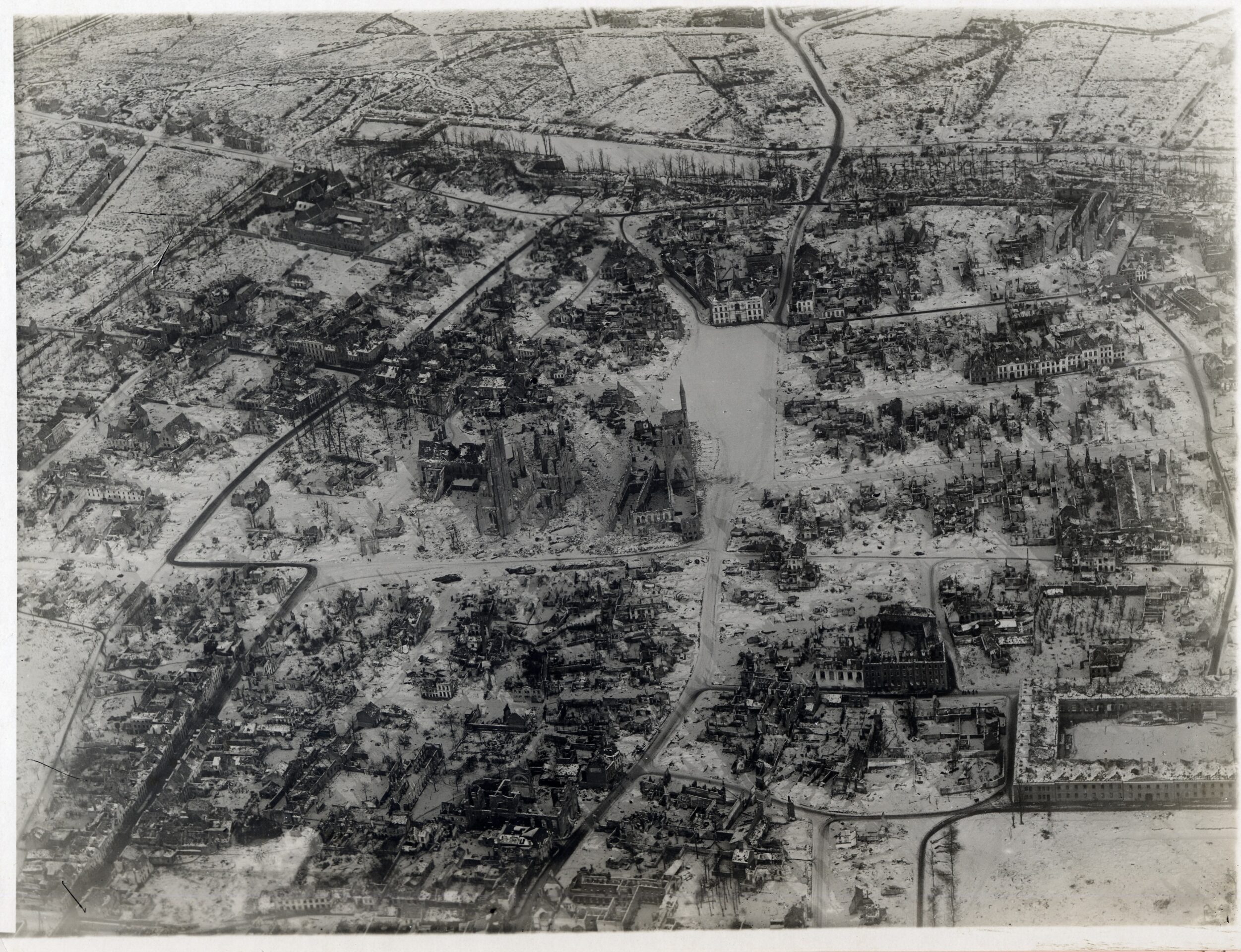
Vertical view of Ypres, nearly razed to the ground after the Great War
The First World War – the Great War, as it was known until 1940 – is often described as the first industrial war. It was also the first conflict to be systematically observed from the air. When the war began, aviation was still in its infancy. The Wright brothers’ first powered flight had taken place just over a decade earlier. Yet by 1915, aircraft were routinely flying over the Belgian front at altitudes of four or five kilometres, carrying heavy cameras and trained observers. In little more than ten years, humanity had learned not only how to fly, but how to use flight to see, record and control the battlefield.
War as innovator
Those early aerial photographers worked under extraordinary conditions. They flew in open cockpits, exposed to freezing temperatures, violent turbulence and constant danger.
Their cameras were manual, heavy and fragile. Glass plates had to be changed by hand while the aircraft shook and shuddered. Exposure had to be judged instinctively. Navigation relied on maps, landmarks and experience.
All of this took place while they were being targeted by anti-aircraft fire from the ground and fighter aircraft from the sky. These men were observers, photographers, intelligence officers and navigators all at once, operating at the limits of both human endurance and early 20th-century technology.
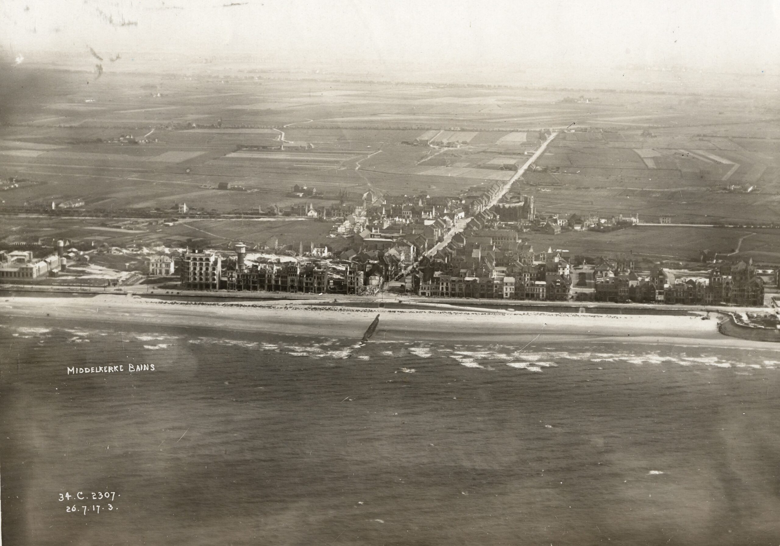
Oblique photo of bomb-damaged Middelkerke (In Flanders Fields Museum)
The speed at which aerial photography developed during the war is astonishing. In the early months of the conflict, pilots and observers were sent up to make visual observations, sketching enemy positions by hand.
Their reports were often doubted by commanders on the ground. To prove what they had seen, some began taking photographs with their own personal cameras.
Within a year, this improvisation had evolved into a professionalised military discipline. Specialised cameras were developed. Automatic plate-changing mechanisms were introduced. Vertical photography became standard practice. Stereoscopic imagery allowed analysts to view the battlefield in three dimensions, revealing hidden trenches, camouflaged bunkers and subtle changes in terrain that could not be seen with the naked eye.
War accelerated innovation at a breathtaking pace. But it also transformed how the conflict itself was fought. Artillery, often described as the most deadly weapon of the First World War, depended entirely on aerial observation. Guns firing from kilometres behind the lines could not see their targets. Aircraft corrected their fire, guided shells onto enemy positions and identified new threats. Without aerial photography, much of the war as we understand it would simply not have been possible.
Crop and soil patterns
My own path into this world began far from the front lines, in an archive. In 2002, I was a master’s student in archaeology at Ghent University. At that time, the archaeology of the First World War was only just emerging as a recognised field in Belgium. Amateur excavations were uncovering trenches and dugouts. Human remains were being discovered during construction works. The physical traces of the war were resurfacing, sometimes quite literally, in the landscape.
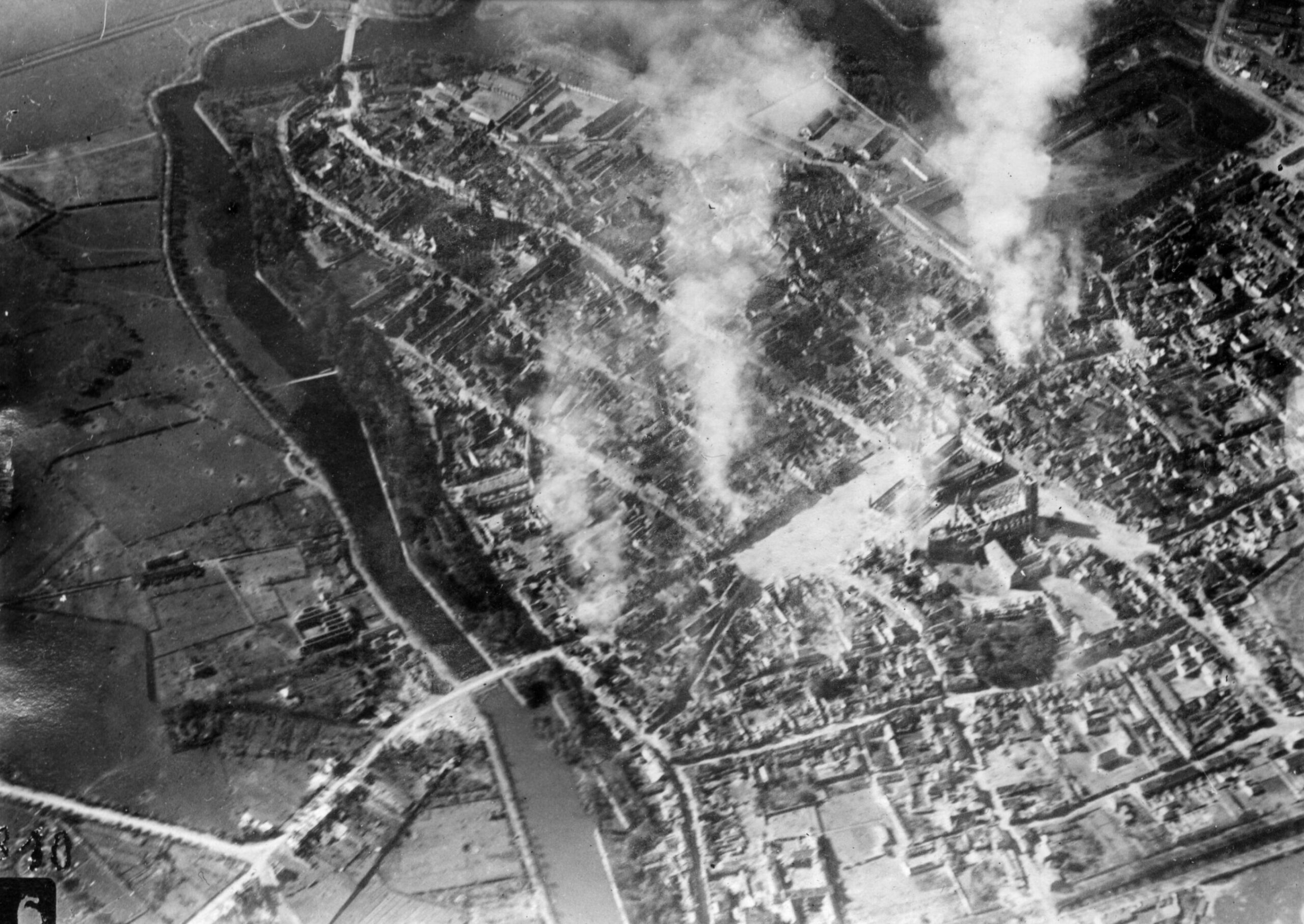
Smoking Ypres seen from above during the Great War
At the same time, Ghent University had a strong tradition of research in aerial archaeology. Flying over Belgium during a dry summer, you can still see traces of ancient ditches, roads and field systems in the crops below. Differences in soil moisture reveal what has long vanished from view. This method had traditionally been applied to prehistoric and medieval archaeology, but it offered intriguing possibilities for studying twentieth-century conflict. I was fascinated by the idea that the First World War might still be written into the land itself, waiting to be read from above.
My supervisor had once catalogued First World War aerial photographs during his civil service. He knew that a substantial but underused collection existed in Brussels. When he suggested that I examine those photographs as part of my research, it felt like the convergence of several interests at once: archaeology, history, landscape, technology and war. That moment shaped the direction of my professional life.
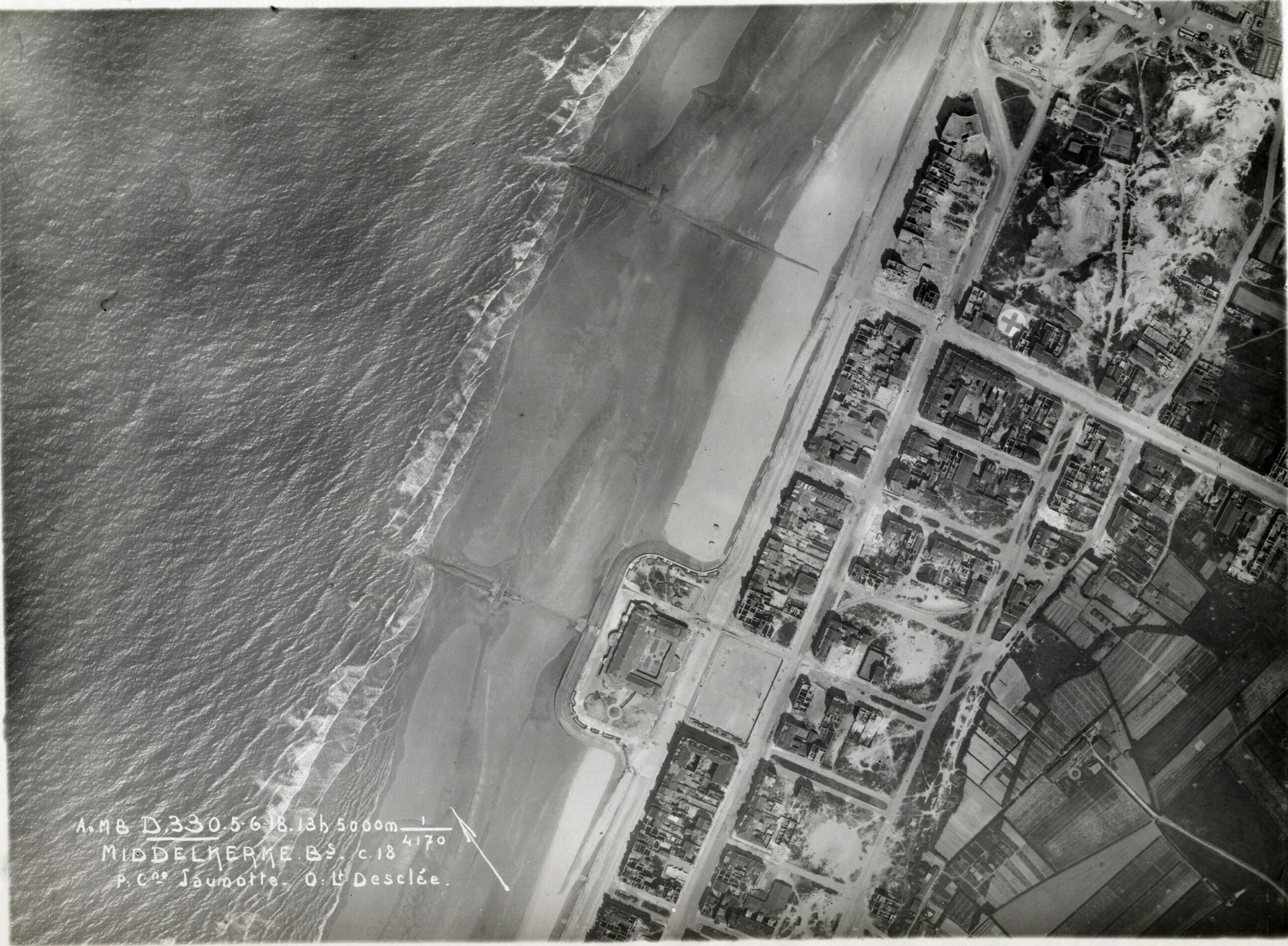
Coastal town of Middelkerke (In Flanders Fields Museum)
The collection I began working with grew to around 25,000 aerial photographs of the First World War. Today, it forms the core of what is probably the largest digitised set of such images anywhere in the world. Yet even that number can be misleading. These photographs represent only a fraction of what was taken. Hundreds of thousands of aerial images survive in archives across Europe, Australia and North America. In total, over half a million First World War aerial photographs remain. Millions more have been lost through neglect, destruction or chance.
Identifying patterns
From the outset, it was clear that looking at individual photographs was not enough. One image, taken in isolation, tells you very little. It is only by comparing thousands of photographs, taken on different dates and from different altitudes, that patterns begin to emerge. My work involved digitising the images, cataloguing them and, crucially, locating them precisely within the modern landscape. Each photograph had to be aligned with present-day coordinates, matching historic features to contemporary maps and satellite imagery.
Once this work was done, the real analysis could begin. Every visible trench, bunker, barbed wire entanglement, gun emplacement and mine crater was mapped. Piece by piece, a hidden landscape re-emerged. The scale of what appeared was staggering. In Belgium alone, more than 6,000 kilometres of trenches were dug during the First World War. These were not simple lines scratched into the earth. They were complex, evolving systems shaped by terrain, technology and relentless enemy fire.
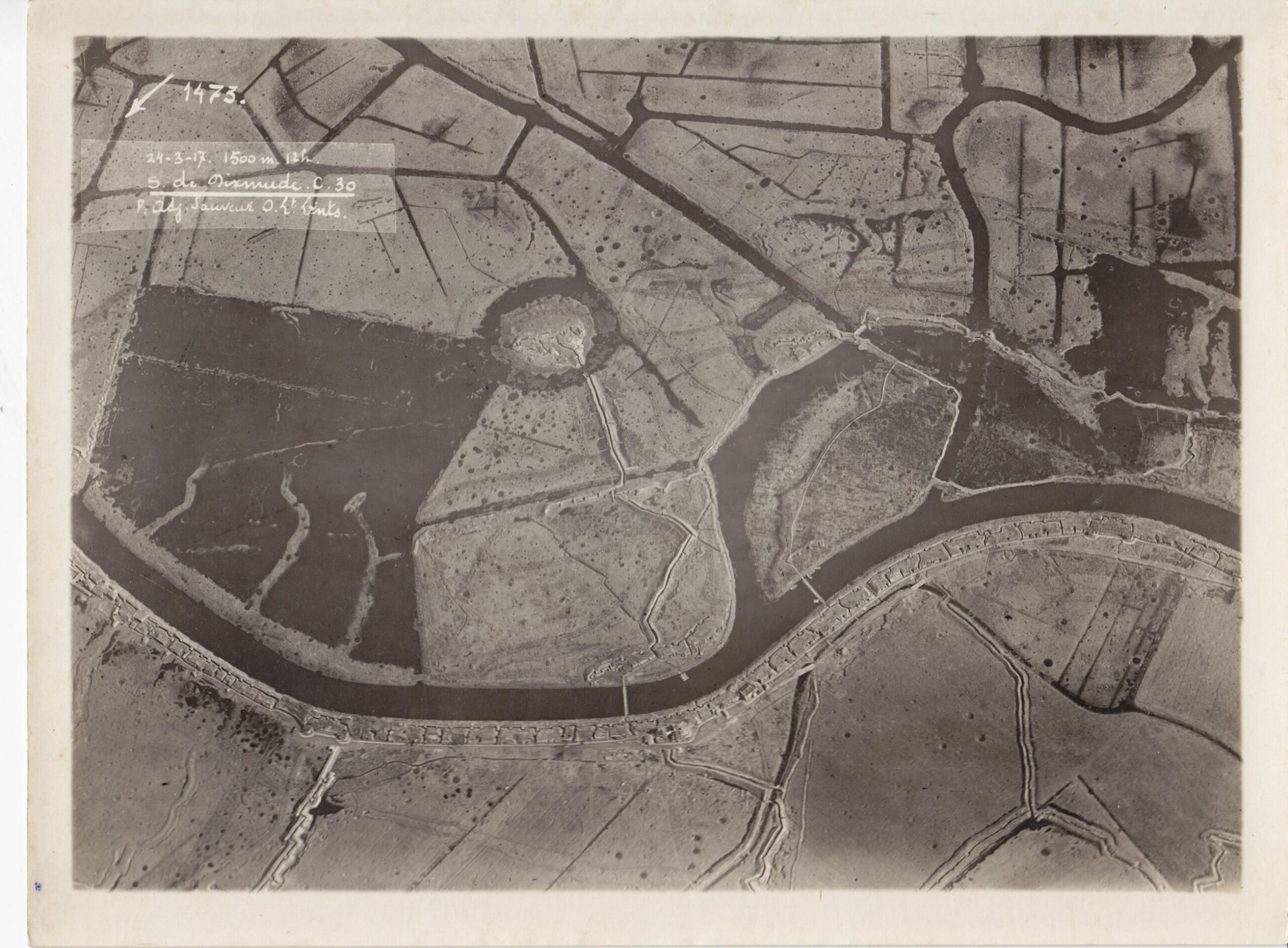
Multilayered landscape south of Dixmude revealing the front line along the Yser, the inundated floodplain and the trenches dug into river embankments.
One of my favourite photographs shows the Belgian front line along the Yser River, near Diksmuide. Taken in March 1917, it is an oblique image, angled rather than vertical, which makes it immediately accessible even to non-specialists. You can see the river, the flooded plains, the raised embankments and the Belgian trenches carved directly into the riverbanks. What this photograph reveals so clearly is the intimate relationship between natural geography and military strategy.
This image is powerful because it shows multiple layers of landscape at once. There is the natural landscape, shaped by water and subtle changes in elevation. Beneath that lies a historical landscape, with medieval field boundaries and the traces of a moated site that has long since disappeared at ground level. On top of both, the military landscape is imposed with brutal efficiency. Trenches, pillboxes and outposts exploit every natural advantage offered by the terrain. War does not erase the past so much as overwrite it.
The photograph also challenges many popular assumptions about the First World War. In this sector, the front line was not a narrow strip of death. No Man’s Land stretched for hundreds of metres, deliberately flooded to form a defensive barrier. The Belgian army used the river as a strategic ally. The war here was static and defensive, shaped as much by geography as by doctrine. From the air, these choices become immediately legible.
Rubble and dust
Elsewhere, the situation was dramatically different. Around Ypres (Ieper in Dutch), the landscape tells a story of relentless destruction. Aerial photographs taken in 1915 show the city still recognisable, its medieval buildings standing amid rising columns of smoke. Only two years later, the transformation is almost total: the photographs reveal a city reduced to geometry. Shell craters scar the market square. Trenches cut through centuries-old fortifications. Buildings dissolve into rubble and dust.
For many people today, Ypres is a place of quiet remembrance, carefully reconstructed after the war. Seeing it erased from above forces a confrontation with the intensity of industrial warfare. At the In Flanders Field Museum, where I work, we use these images to help visitors understand destruction on a scale that words alone struggle to convey. The aerial view makes clear that the city was not damaged by accident, but systematically obliterated.
Passchendaele takes this devastation even further. German aerial photographs from late 1917 show a landscape that appears almost featureless. The village church is reduced to a faint outline. Streets are barely discernible. Thousands of shell holes pockmark the ground. By this stage of the war, trenches had ceased to function as meaningful structures. Artillery had destroyed the terrain so completely that fighting took place in craters and ruins. The landscape itself became a weapon.
Lunar landscape of Passendale 1917, with thousands of shell holes, few remaining trenches and warfare now crater-based (In Flanders Fields Museum)
These images can be difficult to interpret because they reveal such an abstract, almost lunar landscape. But that emptiness is precisely the point. There was nothing left to recognise, nothing left to shelter behind. From above, the war appears as a process of total environmental collapse. It is both impersonal and deeply disturbing.
Some scars remain visible to this day. At Hill 60, near Ypres, British engineers detonated massive underground mines in 1917. The resulting craters, dozens of metres wide and many metres deep, are still clearly visible in the landscape. Aerial photographs show them in astonishing clarity, dwarfing nearby canals and roads. These features are among the most tangible reminders of the war’s subterranean dimension and its long-term impact.
The unfinished war
For archaeologists, these images are invaluable. They let us locate tunnels, predict buried structures and assess what may still lie beneath the surface. This knowledge is not only of academic interest. Construction projects in Flanders regularly encounter unexploded ordnance. Understanding where the fighting was most intense can be a matter of public safety. The aerial photographs continue to have practical value more than a century later.
The importance of aerial photography did not end in 1918. During the Second World War, Belgium was photographed again, this time from even greater heights. Ports, bunkers, airfields and transport networks were documented in meticulous detail. The same principles applied. Control of the air meant control of information. Technology evolved, but the logic remained the same.
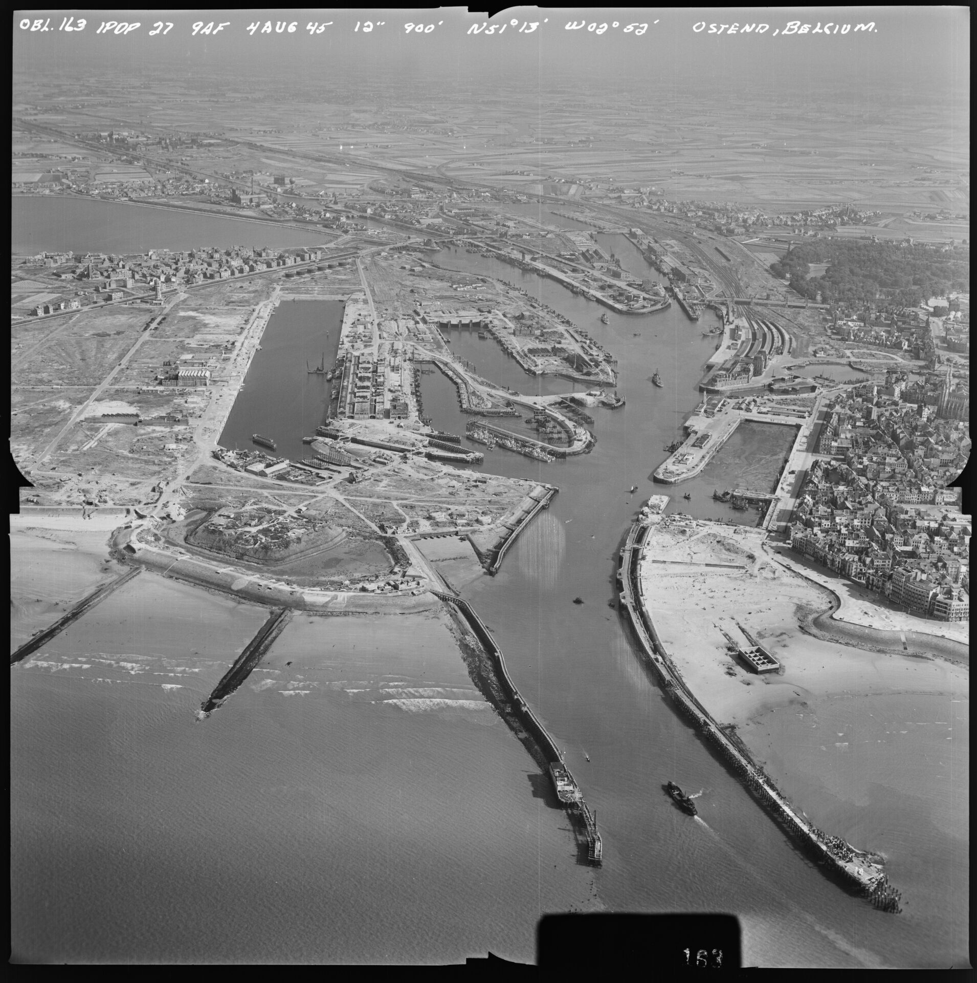
Post-war photo of Ostend talen on 4 August 1945 (National Archives and Records Administration)
Today, satellites and drones perform similar functions. When we watch contemporary conflicts unfold through overhead imagery, for example, in Ukraine, we are witnessing the continuation of a practice that began over the trenches of Belgium. The First World War marked the moment when warfare became permanently tied to remote observation.
Looking at these photographs today creates distance, and that distance can be dangerous. From above, war can appear abstract, almost clean. But every image represents countless individual stories: soldiers digging and waiting, civilians displaced or killed, landscapes poisoned for generations. The photographs may lack visible people, but they are saturated with human presence.
When I look at these images, I do not see beauty. I see a warning. The First World War was the beginning of a way of seeing and fighting that still defines our world. The technology may be more sophisticated today, but the consequences remain the same. Distance does not reduce suffering; it only disguises it.
If there is one lesson these photographs offer, it is this: do not be seduced by distance. Behind every pattern lies a human story. The aerial view can help us understand war, but it should also remind us of its cost. The landscape remembers, and it is our responsibility to listen.
Birger Stichelbaut works with the In Flanders Fields Museum and Province of West Flanders to study the heritage of the First World War.