
Inside a sleepy town in the southern Netherlands you can find...Belgium
Inspecting a map of Baarle-Nassau and Baarle-Hertog, you wouldn't be blamed for assuming that the splattering of national borders was the result of a spilled ink pot by a careless cartographer centuries ago. But you’d be wrong.
Within the Dutch town of Baarle-Nassau lies another: that of Baarle-Hertog, part of the Belgian province of Antwerp. With a total area of just seven and a half square kilometres, the Flemish exclave of Baarle-Hertog is made up of 26 different pockets of land. Of these, 22 are surrounded by the Netherlands, three are situated on the border between the two countries and one is in Belgium itself. In turn the Flemish exclave hides within its boundaries many Dutch counter-exclaves (an exclave inside an exclave).
Confused yet? Residents certainly are. The separate territories have two different mayors, two police forces, two postal services, two bus companies, and are subject to two different sets of national laws.
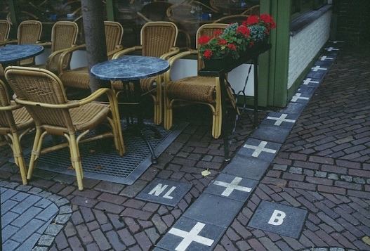
At first glance the mongrel town might seem indistinguishable from any other in the area, with its bakeries, bicycle racks, red brick churches. But, looking closer, questions begin to surface: what do these strange white crosses marking the streets mean? Why are pavements painted with “NL” on one side, “B” on the other?
Legislative nightmare
These white markers pay no attention to obstacles in their path; streets, restaurants and even homes often find themselves split between two countries. House numbers are marked in the colours of their respective nations, and if the border runs straight through the middle of your doorway? Just pick a side.
When the Dutch government introduced restrictions on business opening hours, owners of restaurants on these frontier lines simply swapped customers over to tables on the Belgian side to be able to stay open later.

Yet it is the lead up to the New Year when crossing points really come to life. Thanks to laxer laws on the sale of fireworks in Belgium than the Netherlands, the end of December sees many citizens of Baarle-Nassau make their annual pilgrimage to the famous firework shops of Baarle-Hertog.
And considering that legal drinking starts from age 16 in Belgium (as opposed to 18 in the Netherlands), the Flemish certainly seem to be winning on the party front. But what about taxes?
Buildings caught across both sides of the Dutch-Flemish border pay tax according to which side their front door is located on. Locals wanting to reduce their bill need simply shift their entranceway.
Historical circumstances
Baarle’s Siamese twin towns were born out of a political tussle during the Middle Ages between the Lords of Breda and the Dukes of Brabant. Their treaties and tit-for-tat swaps cleaved up the region and to this day the name of each town bears witness to this history - Hertog, derived from a Dutch word meaning “duke”, and Nassau, a nod to the aristocratic House of Nassau which ruled the city of Breda in North Brabant.
The complex web of lines we see on modern maps began to be sketched out in the 19th century yet continued to be contested until 1995 when the last blob of ‘no-man’s land’ (a small field outside of town) was finally given over to Belgium.
Today, Baarle’s hash of borders is little more a fascinating quirk (and a useful money-spinner for its tourist office). Yet during the First World War these national divides could mark out the difference between life and death. While trench-ridden Belgium was occupied by German armies, the Netherlands was neutral territory. Rather than brightly painted crosses, electric fences separated the two countries, and Baarle-Hertog became a safe haven for lucky refugees who made it across the border as well as a breeding ground for the Belgian resistance.
In our era of Google maps and geotagging, the world can feel dangerously like it is shrinking to fit a geography that has been implacably mapped out, with no arguments necessary or possible. Geopolitical anomalies like Baarle give us hope.
The town’s national borders are not just arbitrary lines, as random as a squeeze of mayonnaise dolloped roughly over some freshly fried frites. They’re a sign that the earth is not quite so fixed and knowable as we fear it might be.
Undefinable places have entrancing power over us. Everyday keen birdwatchers and curious tourists pile into the two 15-passenger boats that are allowed to land on Machias Seal Island, a small patch of sand in disputed waters claimed by both the United States and Canada. Then there are the illegal campers who have to be chased off Pheasant Island (Île des Faisans or Isla de los Faisanes) by either French or Spanish police, depending on which national government is at that time in charge of the uninhabited and off-limits island, which has changed hands between the two countries every six months for the past 350 years.
Rather than dividing us, these borders, the kind that weave together a strange patchwork quilt of different identities, bring people together because they reassure us that there are still parts of the world that cannot be explored, or explained, simply by Google maps.
By Marianna Hunt