
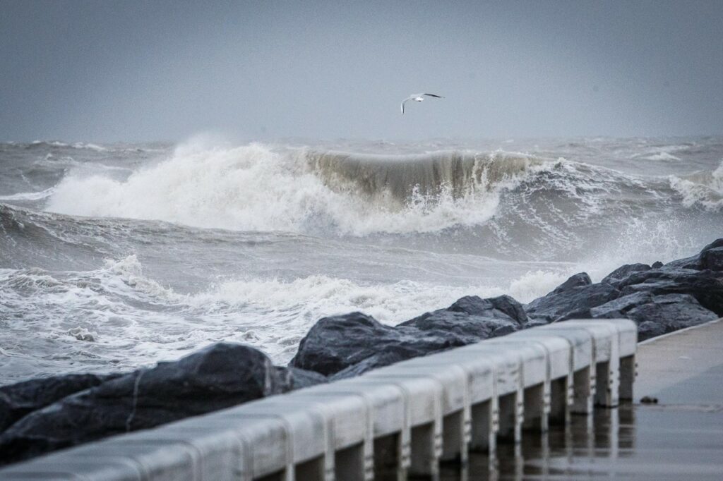
As Belgium prepares for what could be the worst storm in 30 years, a code orange warning has been put out for East and West Flanders and Antwerp where gusts of 150 km/h are expected.
Around 13:00, one measuring station near the Belgian coast (Westhinder) recorded wind of at least 9 Beaufort, which according to the Royal Meteorological Institute (RMI), can be considered a storm.
“Nine Beaufort (Bft) average wind at the Westhinder measuring station now. Eunice also a Belgian storm,” weather reporter David Dehenauw said on Twitter.
9 Bft gemiddelde wind op de meetpaal Westhinder nu. Eunice ook een Belgische storm.
— David Dehenauw (@DDehenauw) February 18, 2022
About an hour later, this rose to 10 Bft, which is considered a “heavy storm," and by 15:30, it even increased to 11 Bft, officially making it a "very heavy storm."
As of 17:00, however, the wind started decreasing at sea and on the coast, according to Dehenauw. "The rest of West-Flanders is following quickly. But locally, there are still gusts of about 100 km/h. This will continue inland in the coming hours."
On Thursday, the country's RMI issued code orange — advising people to be prepared and follow the advice of the competent authorities — for Friday afternoon until Saturday, saying strong wind gusts (up to 150 km/h) are expected to hit East and West Flanders and Antwerp.
Waarschuwing voor wind van 18/02 12u tot 19/02 00u: Tussen vrijdag 14-15u en 18-19u verwachten we een zware zuidwesterstorm (10 Bf) en eventueel zeer tijdelijk en plaatselijk zeer zware storm (11 Bf) ... (https://t.co/sPNybMQZwU) pic.twitter.com/ND8WQ8cYLK
— KMI (@meteobenl) February 17, 2022
The tweet reads: "Wind warning from 18/02 12h to 19/02 00h: Between Friday 14-15h and 18-19h we expect a heavy south-westerly storm (10 Bf) and possibly very temporary and locally very heavy storm (11 Bf)."
The rest of the country has been issued with code yellow for the coming days until Saturday when the heavy gusts are expected to subside.
On Friday morning, Dehenauw said the RMI will likely not issue this code red — which alerts people to take action to "bring themselves, others and if possible their belongings to safety and strictly follow the advice of the authorities" — but warned that in the forecast itself, "hardly anything changes and you have to remain vigilant."
Stay indoors and avoid travel
The storm is expected to pass through Belgium between 14:00 and 19:00 on Friday and will be accompanied by strong gusts of wind, which could result in "widespread damage and serious traffic disruption."
People have been advised to avoid travelling during rush hour on Friday evening and to stay inside as much as possible, especially in the northeastern part of the country.
National railway operator SNCB will partly stop train traffic in Flanders during the afternoon (from 14:00 to 18:00), particularly in East Flanders and Antwerp. Trains will be allowed to travel at a maximum of 80 km/h in the rest of the country.
⚠ Tempête #Eunice : le trafic ferroviaire est suspendu de 14h à 18h sur une partie de la Flandre et la vitesse limitée à 80km/h sur le reste du réseau.
ℹ Les canaux d’information de la #SNCB informeront au mieux les voyageurs de l’évolution de la situation. pic.twitter.com/RHONcj8MLF — SNCB (@SNCB) February 18, 2022
The tweet reads: "Rail traffic is suspended from 2pm to 6pm in parts of Flanders and the speed limit is 80km/h on the rest of the network. The information channels of the SNCB will inform travellers as well as possible about the evolution of the situation."
An increasing number of schools in the affected regions have also decided to close their doors in the afternoon to allow students to get home before the storm hits hardest in the afternoon. The University of Antwerp (UAntwerpen) also announced it is suspending classes from 13:00.
Related News
- Public transport, air and sea travel disrupted due to storm Eunice
- Brussels parks shut as winds rise pending 'orange' storm warning
Various parks across the country will also be closed as a precautionary measure. The police in Brussels announced on Thursday that Bois de la Cambre forest will be closed on Friday from 10:00 until Sunday morning.
? En raison des mauvaises conditions météorologiques, le Bois de la Cambre ? sera fermé ce vendredi (10u) jusqu’à dimanche matin (6h) #Bruxelles ? Wegens de slechte weersomstandigheden, zal het Terkamerenbos?vrijdag gesloten worden (10u) tot zondagochtend (6u) #Brussel pic.twitter.com/0YILix09h6
— PolBru (@zpz_polbru) February 17, 2022
People are advised to call the emergency number 112 if someone's life is in danger and to call 1722 or ask for assistance via www.1722.be if they need assistance from the fire brigade during or after the storm (if no people are in danger).