
The severe flooding across Belgium over the weekend was separate from the fatal floods the week before, but experts warn that climate change could make both occurrences more common.
Intense rain showers caused significant flooding over the weekend in parts of Belgium, including Flanders, which was largely spared from the fatal floods the week before.
Code yellow warnings from the Royal Meteorological Institute (RMI) for more heavy rainfall and thunderstorms across the whole of Belgium remain in effect until at least Monday evening.
Flooding was especially bad in the coastal town of Nieuwpoort on Monday morning.
In less than an hour, some 60 litres of water per square metre fell from the sky there, leaving the district Pemenhoek completely under water.
Basements were flooded, standing water sat on the streets, and the fire brigade responded to a steady stream of calls all day long.
“In the 11 years that I have been living here, this has never happened before,” one Pemenhoek resident told De Standaard.
In Leffinge, Lombardsijde, Oostduinkerke and Sint-Idesbald the quantities rose to more than 30 litres per square metre.
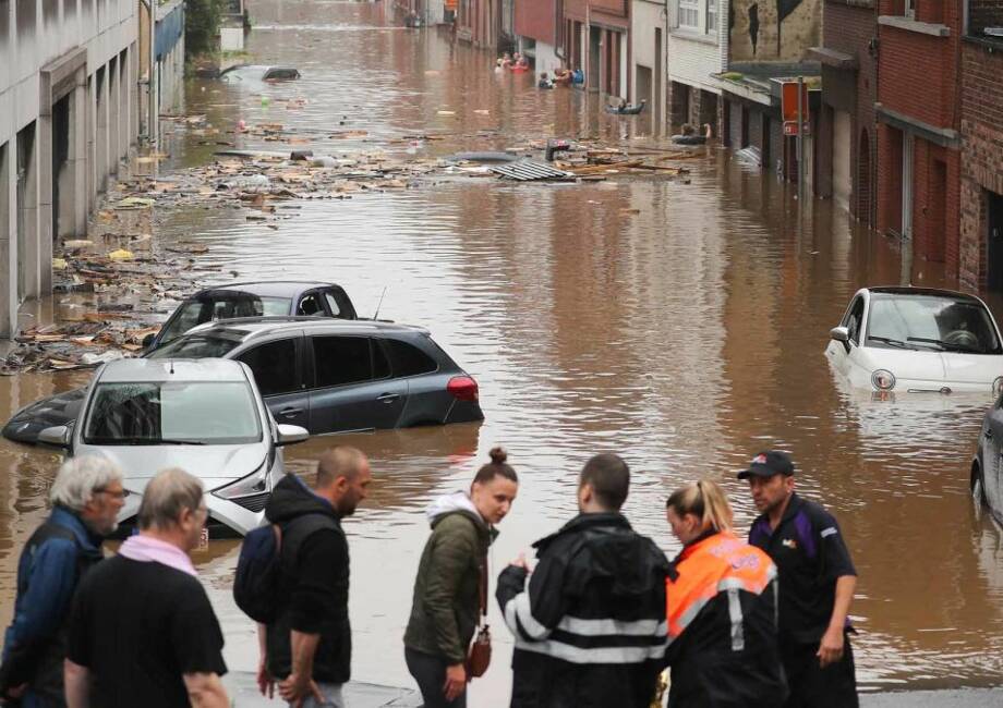
Flooding was also severe in Dinant, a city in the Walloon Region, where cars were swept away in badly flooded streets.
That city was also hit during the deadly flooding that occured the week prior.
But both incidents of floods were completely separate, Meteorologist Frank Deboosere and Professor of hydrology Patrick Willems (KU Leuven) explained to De Standaard in an interview.
The floods of this weekend were pluvial floods, meaning floods caused by heavy rains. The fatal ones that came not long before it were fluvial floods, which occur when bodies of water overflow their banks.
Both types of floods will become more frequent because of climate change, the experts warn.
They say that drought and precipitation will become more extreme, and as temperatures rise, the air can ‘carry’ more water and the rate of rainfall decreases. Therefore, when the skies do open, they’ll be unleashing far greater amounts of water.
It’s already happening.
When comparing rainfall amounts for a specific region over time, it was revealed that a rainstorm with over 40 litres of water falling per square metre in one hour occurs on average once every 14 years - without climate change, this would only happen once every 100 years.
“By the end of this century, heavy rain showers will occur five to ten times more often,” said Willems.
“A heavy shower that used to occur once in a hundred years, will occur once in ten or twenty years.”
These are only statistical averages, Deboosere and Willems emphasise, meaning cities like Dinant could experience another massive flood again in just a few weeks, or go a long period of time without any heavy showers.
Experts unanimously agree that the earth has been in the middle of measurable changes in the weather due to climate change for quite some time.
Earlier this month, American researchers published a study in Nature Communications showing that human-induced climate change has been evident in the statistics of extreme precipitation worldwide since the 1980s.
“We are probably only now really noticing the changes because they are suddenly associated with inconvenience,” said Willems.
“Until now, the fact that the sewage system in a village occasionally overflowed did not attract much attention. But now everyone sees what is going on. The dry summers did not go unnoticed either.”
Because of the floods a week and a half ago, the ground was already saturated with water, making it unable to absorb the new rain that came this weekend.
“But even without the saturated soil, there would have been floods,” said Deboosere.
“From 40 litres of rain per square metre, you have to expect flooding anyway. Dinant was well above that. The saturated soil made it worse than it could have been.”
The heavy rainfall in Wallonia this weekend can also affect Flanders, but the images are more dramatic in the French-speaking regions because of all the valleys, many of which have towns.
Water flows into them from higher hills, bringing with it new destruction and debris from the havoc it caused along the way.
“In Flanders, if 100 litres of rain fall per square metre during a summer storm, the cars don't float away because there are fewer hills,” Deboosere pointed out.
Rather, in Flanders it’s the sewers that overflow because they cannot process all the water.
“You also get floods, but there will be no mudslides like on the slopes in Wallonia,” said Willems.
The weather is expected to return to the normal Belgian dreariness this weekend, with alternating showers and dry periods.
The showers expected over the next few days are not expected to be as substantial as the ones that came this weekend.